Class 10 Geography Chapter 1 Notes of Resources and Development NCERT Solution in Hindi. NCERT Class 10 Geography Question Answer and Important Question Answer, Textual Question answer also Available for Various Board Students like HBSE, CBSE, UP board, Mp Board, RBSE and some other State Boards.
Also Read:- Class 10 Geography NCERT Solution
NCERT Solution for Class 10 Geography Chapter 1 Resources and Development Notes for HBSE, CBSE, MP Board, UK Board, RBSE and other state boards.
Resources and Development Class 10 Geography Chapter 1 Notes
Resource- Everything available in our environment which can be used to satisfy our needs, provided, it is technologically accessible, economically feasible and culturally acceptable can be termed as ‘Resource’.
Classification of Resources –
(a) On the basis of origin – biotic and abiotic
(b) On the basis of exhaustibility – renewable and non-renewable
(c) On the basis of ownership – individual, community, national and international
(d) On the basis of status of development –potential, developed stock and reserves.
Type of Resource in Detail..
On the Basis of Origin –
- Biotic Resources: These are obtained from biosphere and have life such as human beings, flora and fauna, fisheries, livestock etc.
- Abiotic Resources: All those things which are composed of non-living things are called abiotic resources. For example, rocks and metals.
On the Basis of Exhaustibility
- Renewable Resources: The resources which can be renewed or reproduced by physical, chemical or mechanical processes are known as renewable or replenishable resources. For example, solar and wind energy, water, forests and wildlife, etc.
- Non-Renewable Resources: These occur over a very long geological time. Minerals and fossil fuels are examples of such resources. These resources take millions of years in their formation. Some of the resources like fossil fuels cannot be recycled and get exhausted with their use.
On the Basis of Ownership
- Individual Resources: These resources are owned privately by individuals. Many farmers own land which is allotted to them by government against the payment of revenue. Urban people own plots, houses and other property.
- Community Owned Resources: There are resources which are accessible to all the members of the community. Village commons (grazing grounds, burial grounds, village ponds, etc.) public parks, picnic spots, playgrounds in urban areas are best examples.
- National Resources: Technically, all the resources belong to the nation. The country has legal powers to acquire even private property for public good. All the minerals, water resources, forests, wildlife, land within the political boundaries and oceanic area up to 12 nautical miles (22.2 km) from the coast termed as territorial water and resources therein belong to the nation and called national resources. International Resources: The oceanic resources beyond 200 nautical miles of the Exclusive Economic Zone belong to open ocean and no individual country can utilise these without the concurrence of international institutions. These resources are called international resources.
On the Basis of the Status of Development
- Potential Resources: Resources which are found in a region, but have not been utilised. For example, the western parts of India particularly Rajasthan and Gujarat have enormous potential for the development of wind and solar energy, but so far these have not been developed properly.
- Developed Resources: Resources which are surveyed and their quality and quantity have been determined for utilisation. The development of resources depends on technology and level of their feasibility.
- Stock: Materials in the environment which have the potential to satisfy human needs but human beings do not have the appropriate technology to access these, are included among stock. For example, water is a compound of two gases; hydrogen and oxygen. Hydrogen can be used as a rich source of energy. But we do not have advanced technical ‘know-how’ to use it for this purpose. Hence, it can be considered as stock.
- Reserves: Reserves are the subset of the stock, which can be put into use with the help of existing technical ‘know-how’ but their use has not been started. These can be used for meeting future requirements.
Resource Planning
There are some regions which can be considered self sufficient in terms of the availability of resources and there are some regions which have acute shortage of some vital resources. For availability of all resources in all areas are called resource planning.
Land Utilisation
- Forests
Land not available for cultivation
(a) Barren and waste land
(b) Land put to non-agricultural uses, e.g. buildings, roads, factories, etc.Other uncultivated land (excluding fallow land)
(a) Permanent pastures and grazing land,
(b) Land under miscellaneous tree crops groves (not included in net sown area),
(c) Cultruable waste land (left uncultivated for more than 5 agricultural years).Fallow lands
(a) Current fallow-(left without cultivation for one or less than one agricultural year),
(b) Other than current fallow-(left uncultivated for the past 1 to 5 agricultural years).Net sown area
Area sown more than once in an agricultural year plus net sown area is known as gross cropped area.
Classification of Soil ( Important for Exam Perspective )
Alluvial Soils – This is the most widely spread and important soil. In fact, the entire northern plains are made of alluvial soil. These have been deposited by three important Himalayan river systems– the Indus, the Ganga and the Brahmaputra. These soils also extend in Rajasthan and Gujarat through a narrow corridor. Alluvial soil is also found in the eastern coastal plains particularly in the deltas of the Mahanadi, the Godavari, the Krishna and the Kaveri rivers.
The alluvial soil consists of various proportions of sand, silt and clay. As we move inlands towards the river valleys, soil particles appear some what bigger in size. In the upper reaches of the river valley i.e. near the place of the break of slope, the soils are coarse. Such soils are more common in piedmont plains such as Duars, Chos and Terai.
Apart from the size of their grains or components, soils are also described on the basis of their age. According to their age alluvial soils can be classified as old alluvial (Bangar) and new alluvial (Khadar). The bangar soil has higher concentration of kanker nodules than the Khadar. It has more fine particles and is more fertile than the bangar.
Mostly these soils contain adequate proportion of potash, phosphoric acid and lime which are ideal for the growth of sugarcane, paddy, wheat and other cereal and pulse crops.
Black Soil – These soils are black in colour and are also known as regur soils. Black soil is ideal for growing cotton and is also known as black cotton soil. This type of soil is typical of the Deccan trap (Basalt) region spread over northwest Deccan plateau and is made up of lava flows. They cover the plateaus of Maharashtra, Saurashtra, Malwa, Madhya Pradesh and Chhattisgarh and extend in the south east direction along the Godavari and the Krishna valleys.
The black soils are made up of extremely fine i.e. clayey material. They are well-known for their capacity to hold moisture. They are rich in soil nutrients, such as calcium carbonate, magnesium, potash and lime. These soils are generally poor in phosphoric contents. They develop deep cracks during hot weather, which helps in the proper aeration of the soil. These soils are sticky when wet and difficult to work on unless tilled immediately after the first shower or during the pre-monsoon period.
Red and Yellow Soils – Red soil develops on crystalline igneous rocks in areas of low rainfall in the eastern and southern parts of the Deccan plateau. Yellow and red soils are also found in parts of Odisha, Chhattisgarh, southern parts of the middle Ganga plain and along the piedmont zone of the Western Ghats. These soils develop a reddish colour due to diffusion of iron in crystalline and metamorphic rocks. It looks yellow when it occurs in a hydrated form.
Laterite Soil – Laterite has been derived from the Latin word ‘later’ which means brick. The laterite soil develops under tropical and subtropical climate with alternate wet and dry season. This soil is the result of intense leaching due to heavy rain. Lateritic soils are mostly deep to very deep, acidic (pH<6.0), generally deficient in plant nutrients and occur mostly in southern states, Western Ghats region of Maharashtra, Odisha, some parts of West Bengal and North-east regions. This soil is very useful for growing tea and coffee. Red laterite soils in Tamil Nadu, Andhra Pradesh and Kerala are more suitable for crops like cashew nut.
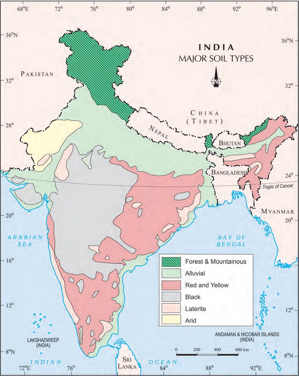
Arid Soils – Arid soils range from red to brown in colour. They are generally sandy in texture and saline in nature. In some areas the salt content is very high and common salt is obtained by evaporating the water. Due to the dry climate, high temperature, evaporation is faster and the soil lacks humus and moisture.
The lower horizons of the soil are occupied by Kankar because of the increasing calcium content downwards. The Kankar layer formations in the bottom horizons restrict the infiltration of water. After proper irrigation these soils become cultivable as has been in the case of western Rajasthan.
Forest Soils – These soils are found in the hilly and mountainous areas where sufficient rain forests are available. The soils texture varies according to the mountain environment where they are formed. They are loamy and silty in valley sides and coarse grained in the upper slopes. In the snow covered areas of Himalayas, these soils experience denudation and are acidic with low humus content. The soils found in the lower parts of the valleys particularly on the river terraces and alluvial fans are fertile.
Soil Erosion and Soil Conservation – The denudation of the soil cover and subsequent washing down is described as soil erosion.
Gullies – The running water cuts through the clayey soils and makes deep channels as gullies.
Bad Land – The land becomes unfit for cultivation and is known as bad land.
Sheet Erosion – The removal of top most layer of soil is called soil erosion or sheet Erosion.